After the Walker Expedition crossed the Wasatch Range – and thanks to Curly, I know they could have done it on horses – the expedition would have found itself in Cache Valley, a wide north-south valley that includes present-day Preston, Idaho and Logan, Utah. Walker could easily have travelled south through Cache Valley toward the Great Salt Lake. I drove south on US 91, which follows the valley, happy to be trailing Walker from the cab of my pickup.
But before long, the highway veered into the hills on the valley’s western edge, and I saw a weather station sitting on top of a hill. I needed a good picture of the valley. I had hoped to make it into Salt Lake City by midafternoon, but it was morning yet – I probably had time to get up to that weather station. I looked for a road to the top, and saw two roads on my GPS that looked like they might get me there. The first road had a closed gate in front of it. But the second road had no gate, so I slowed down and turned in.
I drove over a cattle grate and onto rough road carved into the side of the hill. The two-track dirt road ascended slowly. In places, it ran over bare rocks, which jolted the camper. I crawled over them in low gear. I looked on up the hill, and saw that the road passed through a copse of trees, then turned straight up the hillside. It would be steep, but in four wheel drive I could make it. I was glad I’d be making the climb in the pickup.
But in the copse of trees, the road ended for me. Someone had taken a backhoe and scooped a giant trench across the road. There was now a four-foot-deep hole filled with muddy water. The trees on either side made driving around it impossible. I put the transmission in neutral and set the parking brake.
“Well Duke,” I asked, “want to go for a hike?”
Duke just looked at me, which means that I can interpret his reaction to mean whatever I want. In this way I gained Duke’s assent for the hike. I drank a half-quart of water, put my GPS and camera into my pockets, and got out of the truck.
After crossing the Wasatch, I thought, this little hill will be nothing. Hubris. The road was just as steep as it had looked from the truck and about three times as long. I started hiking. It wasn’t long before I shed my hat, then my jacket and the handkerchief I had tied around my neck. The wind was ripping, and I was out of breath. Duke ran on up the trail then turned and waited on me. I took a break. I turned toward into the wind as I panted to see if the wind’s velocity would fill my lungs faster. It didn’t. On up the trail, Duke sat down to wait, ostensibly because it was taking me a long time to reach him but really because he wanted to rub in his superior hill-climbing abilities.
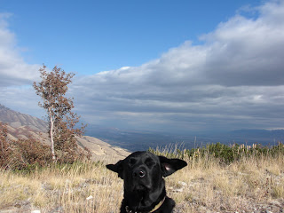
Duke showing up my hiking skillz.
This is how windy it was.
But the forty-degree wind did cool me down enough to continue the hike without sweating into my tee shirt, which would have made me cold later. I double-stepped. And bit by bit, I made it up to the weather station, then on further to a promontory overlooking the valley. It took about forty-five minutes. And no wonder – when I later plugged my GPS route into my computer, I learned that the “hill” I’d climbed was Mount Pisgah and that I’d climbed just over 1000 feet from where I stopped my truck.
The view from the top was pretty, and informative. I realized that Cache Valley didn’t run all the way to the Great Salt Lake – the expedition would also have had to cross the Wellsville Mountains, which included Mount Pisgah, on which I stood. My perch afforded me not only an excellent view of Cache Valley and the Great Salt Lake beyond the Wellsville Mountains, but also of the surrounding roads. I could see that US 91 followed an easy route through the Wellsville Mountains. Walker could have followed it with no problem.
Cache Valley.
By looking through the pass to the left of Duke, you can just make out the Great Salt Lake.
US 89 follows an easy route through the Wellsville Mountains.
So I began the descent back to my truck, thinking about what I’d seen. The road was just as rocky and steep as it had been on the way up. My right knee hurt like the devil. Not 100% recovered from the Wasatch crossing, apparently. I kept my right leg mostly stiff as I made the descent, relying on my left leg to lower me down the hill. I remembered the view from the top. I’d seen another road besides US 91. There was another two-track dirt road leading from the US 91 to the top of Mount Pisgah, this one without barriers. And there had been a truck parked at the weather station. Damnit.
After reaching the Great Salt Lake, Duke and I stopped into the Bear River Migratory Bird Refuge so I could do some research and writing. We took a break to work on Duke's water retrieves. Duke is a good retriever, but where possible he prefers the easy way out.


No comments:
Post a Comment